

Excellent study material for all civil services aspirants - being learning - Kar ke dikhayenge!
Plate tectonics and formation of mountains - Part 1
1.0 Rocks
Rocks are the solid constituents of earth's surface containing minerals in various proportions. They can be formed from a number of processes. Some rocks come readymade from under the surface of earth and are brought out through volcanoes and others are formed on the spot during eruptions. Some also get their shape and nature from the processes occurring on the surface of earth. The place of origin, nature of elements and processes determine the final product.
Chemical and mineral compositions: They are the rock DNA. They play a large part in determining their place of origin. For example, rocks from deep below the surface contain a larger proportion of higher metals as compared to others.
Texture and structure: Texture refers to the size, shape and orientation of the grains. In lay terms, texture is the feeling you get when you rub your fingers over a piece of rock. On large scale, texture determines the structure and in turn physical properties like permeability, brittleness, etc.
Mode of occurrence: The process which led to the formation of a rock also determines the final look and feel of the rock. For example, lava which cools down faster results in rocks which are more crystalline than the one which cools down gradually.
Rocks have only three main classifications, namely Igneous, Sedimentary and Metamorphic. The complex part is that each one has sub-categories!
1.1 Igneous rocks
Igneous rocks are formed by the cooling and solidification of magma (layer of molten mass of minerals below earth's crust) from beneath the Earth's surface. They reach the surface of the Earth through volcanic fissures. The process is called crystallization because most of the igneous rocks are crystalline in nature. Igneous rocks have three sub-classifications:
Acidic & Basic: Those rocks which contain high proportion of silica are called Acidic and those high in basic oxides like Iron, Magnesium, Aluminium, etc. are called Basic.
Plutonic & Volcanic: The molten rocks which solidify before coming to the surface are called Plutonic rocks. In contrast to this, Volcanic rocks are the ones which solidify after molten lava reaches the Earth's surface.
Intrusive - Extrusive: These are the other names for Plutonic and Volcanic, respectively.
1.2 Sedimentary rocks
These types of rocks are formed by the accumulation of sediments (broken down pieces) over a long period of time usually by the action of water and wind. They are also called stratified rocks because they form in layers. They often contain various types of fossils (remains of organic matter). They are sub-classified on the basis of their origin mechanism.
Mechanically formed sediments: These rocks are formed by the cementing of material derived from other rocks. They are generally used for building materials as Sandstone, Clay, Sand and Gravel. Quartz is also formed by this process.
Organically formed sediments: They are formed by the remains of living organisms such as shell fishes and corals. The Great Barrier Reef of Australia is a great example of it. Limestone, Coal and Chalk are also examples of these type of rocks. They are sub-classified as:
Calcareous: Formed by the remains of living organisms. Some examples are Limestone and Chalk.
Carbonaceous: Formed by the remains of Vegetative matter in swamps and forests. Its examples are Peat and Lignite.
Chemically Formed Sediments: These types of rocks are chemicals which have precipitated from solutions of some form. Gypsum is one such example formed by the evaporation of salt lakes which have a high level of salinity. Similarly, chemical rocks like Potashes, Rock Salts and Nitrates are formed.

1.3 Metamorphic rocks
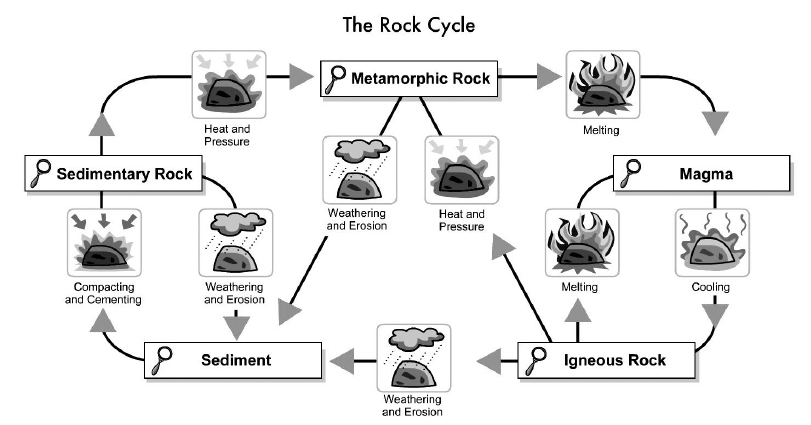
It is easy to define Metamorphic rocks. But its definition opens a Pandora's Box of convertibility of rocks. This process of conversion of one type of rocks into another is a continuous one and is called Rock Cycle.
The Rock Cycle is a way to depict the changes in rocks from one form to another in a recurring sequence. It was first suggested by James Hutton, the founder of modern geology. Let us examine the Rock Cycle.
Weathering and Erosion: This refers to the action of wind and water. It leads to the segmentations and layering of other types of rocks.
Deposition and Diagenesis: After weathering and erosion the rocks remain buried. They undergo chemical, mechanical and biological change called diagenesis to form sedimentary rocks.
Pressure and Heat: This refers to the conditions of underground rocks which undergo high pressure and temperatures and are turned into metamorphic rocks.
Conversion of Rocks back to Magma: This happens around seismic zones. When two tectonic plates strike each other, chances are that one of them will slide underneath. This layer then turns into magma and gets recycled on some other part of the earth.
Rock Cycle and Tectonic plates movement

2.0 CONTINENTAL DRIFT
The continental drift theory says that once all the continents were joined in a super-continent, called Pangaea. Over a vast period of time, the continents drifted apart to their current locations. Alfred Wegener first supported the idea of continental drift.
Centuries ago when the first maps of the Atlantic Ocean were drawn, geographer Abraham Ortellus noted the similarity between the coastlines of Africa, Europe and the Americas in the third edition of his Thesaurus Geographicus, published in 1596. Ortellus, adapting Plato's story of the demise of Atlantis, suggested that America was "torn away" from Europe and Africa and that the "projecting parts of Europe and Africa" would fit the "recesses" of America.
Such observations were little more than idle speculation until Austrian climatologist Alfred Wegener used the fit of opposing coastlines as one of the pieces of evidence to support his hypothesis of continental drift. Continental drift proposed that the continents were once assembled together as a single supercontinent Wegener named Pangaea. Wegener was unable to suggest a suitable mechanism to explain the motion of the continents across Earth's surface and his hypothesis received relatively little support until technology revealed the secrets of the ocean floor.
Wegener's explanation of continental drift in 1912 was that drifting occurred because of the earth's rotation. This explanation and his theory were not widely accepted. Prior to Wegener, however, many had noted that the shapes of the continents seem to fit together, suggesting some schism in the past.

Before the 1950s, the concept of the continental drift, for the most part, was not even entertained as plausible. In the 1950s and the years that followed, however, geologists began to consider the theory, and in the 1960s, most geologists came to accept that the theory may well be possible. Several factors point to the change in accepting the continental drift theory.
Fossil records from separate continents, particularly on the outskirts of continents show the same species. Even the mineral specimens along the supposed break lines of the continents are nearly identical. Some identical species exist on certain continents, like an earthworm common to both Africa and South America suggesting the species could not have spontaneously arisen on both continents without some variations.
He believed that the continents were slung towards the equator on the spinning Earth by a centrifugal effect, while the westward movement of the continents was due to the tidal force of the Moon and the Sun. The theory was rejected first by most geologists and geophysicists, largely because of a lack of viable mechanism. Wegener was dismissed as a crank. His critics claimed, with some justification, that he had carefully selected those evidence, supporting his hypothesis, ignoring contrary evidence. Where, for instance, were the 'wakes' or 'tracks' through old seabed that the migrant continents would leave? But a few geologists sided with Wegener. The main observations in support of Wegner's theory were:
Fit of the continents: The opposing coastlines of continents often fit together. An even better fit occurs if the edge of the continent shelf is used, a little offshore. Wegener was not the first person to notice the similarities between continental coastlines. Early map makers several centuries before had made the same observation.
Match of mountain belts, rock types: If the continents are reassembled as Pangaea, mountains in west Africa, North America, Greenland, and western Europe match up.
Distribution of fossils: The distribution of plants and animal fossils on separate continents forms definite linked patterns if the continents are reassembled. For example, fossils of the reptile Mesosaurus are found in both southern Africa and South America. The fossil is preserved in rocks deposited in streams so it is concluded that the reptile lived in freshwater environments. Mesosaurus could not have traveled across an ocean between the continents. Either the continents were side-by-side or Mesosaurus evolved separately on two continents at the same time, an unlikely explanation. A fossil fern, Glossopteris, is found on several continents with different climates today. Wegener believed the distribution of Glossopteris could be accounted for by initially spreading across Pangaea prior to the breakup of the supercontinent.
Paleoclimates: Wegener assembled geologic evidence that showed that rocks formed 200 million years ago in India, Australia, South America, and southern Africa all exhibited evidence of continental glaciation. Such a glaciation would have required a global ice age if the continents were in their present positions. However, at the same time there were tropical swamps in southern Ohio and much of the eastern U.S. Clearly, the rest of the world was not in a deep freeze. Such apparently widespread glaciation could be explained if the continents were located close to the South Pole.
Evidence for continental drift was embraced by some scientists but was rejected by others, primarily because Wegener was unable to propose an acceptable mechanism to cause the continents to move. He suggested that the continents pushed through the rocks of the ocean floor because of tidal forces; much like a plow cuts through the soil. Unfortunately for Wegener this idea was shown to be physically impossible. Consequently, continental drift, although providing a compelling explanation for the distribution of common features on different continents, would wait another 50 years to make a triumphant return.

3.0 PLATE TECTONICS
Plate tectonics is the scientific theory that attempts to explain the movements of the Earth's lithosphere that have formed the landscape features we see across the globe today. By definition the word "plate" in geologic terms means a large slab of solid rock. "Tectonics" is a part of the Greek root for "to build" and together the terms define how the Earth's surface is built up of moving plates.
The theory of plate tectonics says that the Earth's lithosphere is made up individual plates that are broken down into over a dozen large and small pieces of solid rock. These fragmented plates ride next to each other on top of the Earth's more fluid lower mantle to create different types of plate boundaries that have shaped the Earth's landscape over millions of years.
In 1929 Arthur Holmes, a British geologist, introduced a theory of thermal convection to explain the movement of the Earth's continents. He said that as a substance is heated its density decreases and it rises until it cools sufficiently to sink again. According to Holmes it was this heating and cooling cycle of the Earth's mantle that caused the continents to move. This idea gained very little attention at the time.
3.1 Sea Floor spreading
The 1960s was the most crucial phase in development of the plate tectonics theory. By the 1960s Holmes' idea began to gain more credibility as scientists increased their understanding of the ocean floor via mapping, discovered its mid-ocean ridges and learned more about its age. In 1961 and 1962 scientists proposed the process of sea floor spreading caused by mantle convection to explain the movement of the Earth's continents and plate tectonics. Extensive exploration of the ocean floor and mapping of the ocean surface intensified. The observations of the GLOMAR expedition disputed the idea that the ocean bed was a flat monotonous basin. Many observation of the ocean floor could not be explained till Harry Hess and Dietz came up with the idea of sea floor spreading.
New oceanic crust is created as large slabs of the Earth's crust split apart from each other and magma wells up to fill the gap. As they slowly move away from each other beneath the ocean floor, hot magma from the Earth's mantle bubbles to the surface.
This magma is then cooled by seawater. The new rock forms a new part of the Earth's crust. Seafloor spreading occurs along mid-ocean ridges-large mountain ranges rising from the ocean floor.
As one moves away from the ridge the age of the crust increases. The newest crust is located closest to the ridge. The Mid-Atlantic Ridge, which separates the North American plate from the Eurasian plate, and the South American plate from the African plate, is the site of new oceanic crust in the middle of the Atlantic Ocean.
Over time, new oceanic crust pushes older crust farther away. New bodies of water and even continents can be created through seafloor spreading. The Red Sea, for example, was created through seafloor spreading, as the African plate and the Arabian plate tore away from each other. Today, the northern Sinai Peninsula connects the Middle East (Asia) with North Africa. Eventually, geologists predict, seafloor spreading will expand the Red Sea so that it will completely separate the two continents.
Rift valleys, which exist on continental crust as well as oceanic crust, can be created by seafloor spreading. Two of the largest rift valleys in the world, the Mid-Atlantic Ridge and the East Pacific Rise, are products of seafloor spreading.
Subduction is the opposite of seafloor spreading. Seafloor spreading creates new crust. Subduction destroys old crust. The two forces roughly balance each other, so the shape and diameter of the Earth remains constant.
3.2 Principles of Plate Tectonics today

There are three main driving forces for the movement of the Earth's tectonic plates. They are mantle convection, gravity and the Earth's rotation. Mantle convection is the most widely studied method of tectonic plate movement and it is very similar to the theory developed by Holmes in 1929. There are large convection currents of molten material in the Earth's upper mantle. As these currents transmit energy to the Earth's asthenosphere (the fluid portion of the Earth's lower mantle below the lithosphere) new lithospheric material is pushed up toward the Earth's crust. Evidence of this is shown at mid-ocean ridges where younger land is pushed up through the ridge, causing the older land to move out and away from the ridge, thus moving the tectonic plates.
Gravity is a secondary driving force for the movement of the Earth's tectonic plates. At mid-ocean ridges the elevation is higher than the surrounding ocean floor. As the convection currents within the Earth cause new lithospheric material to rise and spread away from the ridge, gravity causes the older material to sink toward the ocean floor and aid in the movement of the plates. The Earth's rotation is the final mechanism for the movement of the Earth's plates but it is minor in comparison to mantle convection and gravity.
As the Earth's tectonic plates move they interact in a number of different ways and they form different types of plate boundaries. Divergent boundaries are where the plates move away from each other and new crust is created. Mid-ocean ridges are an example of divergent boundaries. Convergent boundaries are where the plates collide with one another causing the subduction of one plate beneath the other. Transform boundaries are the final type of plate boundary and at these locations the no new crust is created and none is destroyed. Instead the plates slide horizontally past one another. No matter the type of boundary though, the movement of the Earth's tectonic plates is essential in the formation of the various landscape features we see across the globe today.
Plates are typically composed of both continental and oceanic lithosphere. For example, the South American plate contains the continent of South America and the southwestern Atlantic Ocean. Plate boundaries may occur along continental margins (active margins) that are characterized by volcanism and earthquakes. Continental margins that do not mark a plate boundary are known as passive margins and are free of volcanism and earthquakes. The Atlantic coastlines of North and South America are examples of passive margins.
Major Plates - Africa Plate, Antarctic Plate, Indo-Australian Plate, Australian Plate, Eurasian Plate, North American Plate
South American Plate, Pacific Plate
Minor Plates - There are dozens of smaller plates, the seven largest of which are:
Arabian Plate, Caribbean Plate, Juan de Fuca Plate, Cocos Plate, Nazca Plate, Philippine Sea Plate, Scotia Plate

3.3 Earthquakes and Volcanoes
Scientists had long recognized that volcanoes and earthquakes were present in greatest concentrations around the rim of the Pacific Ocean which today is known as the ring of fire. The Pacific Ring of Fire (or just The Ring of Fire) is an area where large numbers of earthquakes and volcanic eruptions occur in the basin of the Pacific Ocean. In a 40,000 km (25,000 mi) horseshoe shape, it is associated with a nearly continuous series of oceanic trenches, volcanic arcs, and volcanic belts and/or plate movements. The Ring of Fire has 452 volcanoes and is home to over 75% of the world's active and dormant volcanoes. It is sometimes called the circum-Pacific belt or the circum-Pacific seismic belt.
Seismologists Kiyoo Wadati and Hugo Benioff noted that the focal depths of earthquakes became progressively deeper underlying ocean trenches. Prior to the seafloor spreading hypothesis there was no obvious explanation for the presence of these Wadati-Benioff zones. Now it is widely accepted that earthquakes occur as one plate bends and fractures as it descends beneath another into the asthenosphere.

The ocean floor was being pulled or pushed into the mantle where it was heated to form magma which in turn generated volcanoes. The destruction of the oceanic lithosphere caused earthquakes down to depths of 700 to 800 km (440-500 miles), explaining the presence of the deepest earthquakes adjacent to oceanic trenches. The term subduction zone was coined to refer to locations marked by Wadati-Benioff zones where the oceanic lithosphere is consumed adjacent to a trench.
The Plate tectonics theory joined continental drift to seafloor spreading to propose:
- The plate boundaries are mainly represented by oceanic ridges and trenches.
- Interactions at plate boundaries cause volcanic activity and earthquakes.
- The plates are in motion, moving away from ridges and toward trenches.
- Plates descend into the mantle below trenches in subduction zones.
- Plates typically contain both oceanic and continental lithosphere.
- Oceanic lithosphere is continually created and destroyed.
- Continental lithosphere cannot be destroyed but continents can be subdivided and assembled into supercontinents.
Global Earthquake Activity

3.4 Plate Motions
The rates and directions of plate motions were originally determined by computing the distance of oceanic floor of a known age from the oceanic ridge system. Rates were computed by dividing age (years) by distance (centimeters). Such simple but effective calculations were compared to motion rates determined using the age of volcanic islands formed above mantle hot spots. Some volcanic islands in the interiors of plates form above fixed plumes of magma rising from the mantle. The locations of these mantle plumes are known as hot spots. The islands form as the plate moves over the magma source, much like a tectonic conveyer belt. Islands are progressively older with increasing distance from the hot spot. The relationship between age and distance yields the rate of plate motion.
Today satellite technology is used to determine the current rates of plate motion. Satellites anchored in space can record tiny movements of fixed sites on Earth, thus constraining the motions of plates. Rates of seafloor spreading range from a little as 1-2 centimeters per year along the oceanic ridge in the northern Atlantic Ocean to more than 15 cm/yr along the East Pacific Rise spreading center. Current seafloor spreading rates are approximately five times higher for the East Pacific Rise than the Mid-Atlantic Ridge. Spreading rates changed through time but consistently higher rates in the Pacific Ocean basin can account for the contrast in size of the Atlantic and Pacific Oceans. The Pacific Ocean floor would be even wider if oceanic crust were not consumed at subduction zones along much of its margin.


